


Backcountry Site Information
Check out a new version of Keji Backcountry and Mainland
campsites interactive map produced by
MapDev
Technology Solutions Inc.
https://www.kejimap.ca/
GPX
data for navigation
Navigate using a GPS device
Download GPX data to your personal GPS device for
navigation in the field.
GPX data is available
for many backcountry features including:
Click here for
Zipped Backcountry gpx file
contains the following files
-campsites and
cabins
- backcountry trails
- portages
-
launch sites and picnic areas
- firewood
Data
source: Parks Canada, 2023
Backcountry firewood changes
Beginning in 2025, free and unlimited firewood will no longer be provided for backcountry campsites. Campers who choose to have a campfire must purchase firewood at the Visitor Centre or Campground Kiosk and transport it to their campsite. Campers will otherwise rely on the appliances they bring with them for their cooking, heating, and entertainment needs
Navigation buoys will no longer be on Kejimkujik Lake.
Visitors must come prepared to navigate to their
campsite via map and compass and GPS.
Cliquez sur-la pour le Français
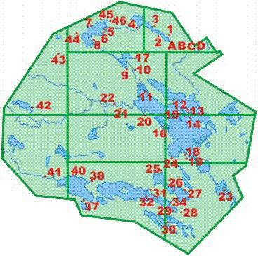
Backcountry or wilderness camping
at Keji is a special experience.
This map shows you the location of all of the
wilderness sites.
The information provided here is for trip
planning purposes only.
You should purchase the Backcountry Guide at the
Visitor Centre before going on any trip into the
backcountry.
All lake or stream drinking water should be filtered or
boiled.
Starting Feb 11h, 2026 at 8am
Atlantic for the period of May 15 - Oct 31 all
reservations will be on a site-specific basis. $11.00
non-refundable reservation fee applies for online and
$13.50 for telephone
Reserve on-line at
www.reservation.pc.gc.ca or by calling
1-877-737-3783
During
the summer, there is a 2 night stay limit per site.
Sites C, 7 and 12 are available for groups of 7
to 10. All
of the other sites are available for groups of 1 to 6.
On the map below, click on any
backcountry campsite number for its details or on any
section for an enlarged map.
